![[OLD SEMESTER] 15-104 • Introduction to Computing for Creative Practice](https://courses.ideate.cmu.edu/15-104/f2022/wp-content/uploads/2023/09/stop-banner.png)
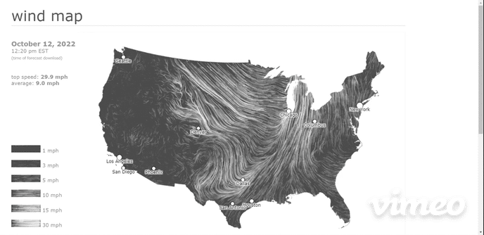
Wind Map is a live visualization of the current direction and wind speeds across the United States. The wind vectors combine to appear almost as smoke churning at different speeds across the country. This project appeals to me visually because it captures the idea of constant change. It can at times be a peaceful flow and at other times it appears agitated and angry. It can appear both ways on the same map depending on where attention is focused.
This project is not limited to weather. It is aesthetically pleasing and useful. It is beautiful and intriguing enough to be on display at the MoMA. At the same time, diverse groups have found its data useful. Birdwatchers have used it to track migration patterns, and cyclists have used it to plan trips. Conspiracy theorists have even used it to track “chemtrails”. This visualization allows this vast, changing dataset to be useful in ways that are impossible with the raw data.
The underlying data for the Wind Map is from the National Digital Forecast Database which provides near term forecasts that are updated once per hour. The visualization was created by Fernanda Viégas and Martin Wattenberg, engineers from the visualization research lab at Google. The entire project is written in html and javascript. A live link to the Wind Map can be found here.