![[OLD FALL 2020] 15-104 • Introduction to Computing for Creative Practice](../../../../wp-content/uploads/2021/09/stop-banner.png)
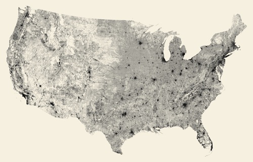
An Information Visualization project that I really admire is All Streets Limited by Ben Fry. In his work, Fry created an intricate map of all the streets in the 48 states of the United States. To achieve this incredible work, Fry translated data from the U.S Census Bureau into a map by first, using Perl.Next to parse and filter data. Writing in javascript, Fry applied the Albers equal-area conic projection to transform latitude and longitude coordinates. Later, he converted his work into print. I really enjoy looking at his work as it is a great illustration of how the interconnectedness of little elements–small streets and roads–can make up a system–the map of the United States–showing the complexity that is not usually tangible or is overlooked. His work reveals the universal truth of how things operate and the power of systems–from an atom to the universe.
Link : https://3rdfloor.fathom.info/products/all-streets
Title: All Streets Limited
Creator: Ben Fry
Year: 2007