![[OLD FALL 2018] 15-104 • Introduction to Computing for Creative Practice](https://courses.ideate.cmu.edu/15-104/f2018/wp-content/uploads/2020/08/stop-banner.png)
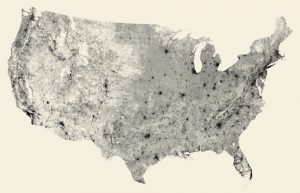
Ben Fry works head of a design and software consultancy where he combines his knowledge in computer science and graphic design to generate visual data of different sets of information. As a fan of geography and integration of urban areas and habitation, this project called “All Streets” is basically what the title says it is – using his software of TIGER/Line shapefile to generate a series of tiles and prints out a map of every street in that country.
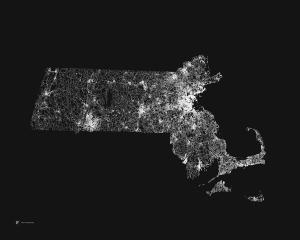
What makes me admire these sets of work so much is the negative spaces that generate in between the lines. One can see where the urban areas are, which spaces are largely inhabited and which may be resourcefully insufficient.

The funny thing is that I have to remind myself every time that this is not a density population map or a light pollution map – these are simply streets; however, the magnitude of them is directly correlated to the number of people that use them in a given radius.