![[OLD FALL 2018] 15-104 • Introduction to Computing for Creative Practice](https://courses.ideate.cmu.edu/15-104/f2018/wp-content/uploads/2020/08/stop-banner.png)
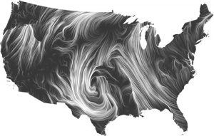
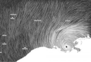
This week, I decided to look at the wind map developed by Marten Wattenberg and Fernanda Viegas. Featured in the MOMA as the first web artwork to be a part of the museum’s permanent collection, it is a living portrait of the wind currents over the nation. I decided to go with this project because it only uses HTML and Javascript, using the data from the National Digital Forecast Database.
This was a really interesting project to me because through the wind map you’re also learning about the climate of the states and why the enivronment/terrain is the way that it is. I appreciate the artists’ choices in making the map monochromatic so the viewer isn’t influenced to believe anything about the terrain that the currents are covering. The idea of the map updating in real time allows the viewer at MOMA to apply what they’re seeing to a larger scale. The map also allows the viewer to see the progress of a natural disaster and serves as a learning experience.