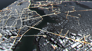
Robert Hodgin is an interactive director and co-founder of Rare Volumes. His project “Taxi, Taxi!” shows NYC Open Data taxi against routes created with Open Street Map. This digital installation is shown through a 3D model of New York City. This project was shown in Samsung 837 which is a three story display. He used Cinder C++.

I admire how inclusive this project is. Everyone can relate to looking on their smartphone to find the fastest and shortest way to get to their destination. This digital installation can help people understand the main routes for taxis so they can decide whether it is a good idea or not to take it. In addition, because it is 3D it makes it easier to understand the map. I feel like sometimes when I am on on the Apple Maps it is difficult to read because it is flat and I can not comprehend the map as well. I understand that right now the design is only an installation, but I feel like in the future they could create for smartphones so that everyone can use. I think I have slight knowledge about the algorithm that was used to generate this work. In high school, I took Geospatial Analysis, so we would create various routes depending on the prompt with Open Street Maps. In order to do so, we had to collect data points so that it was easier to create on the software. Through that program you could create buffers, paths, and other ways of identifying data points on a map. I really enjoyed how clean and simple the design was. Usually, it feels like maps are so overwhelming with so much information, but this one didn’t.

![[OLD FALL 2019] 15-104 • Introduction to Computing for Creative Practice](wp-content/uploads/2020/08/stop-banner.png)